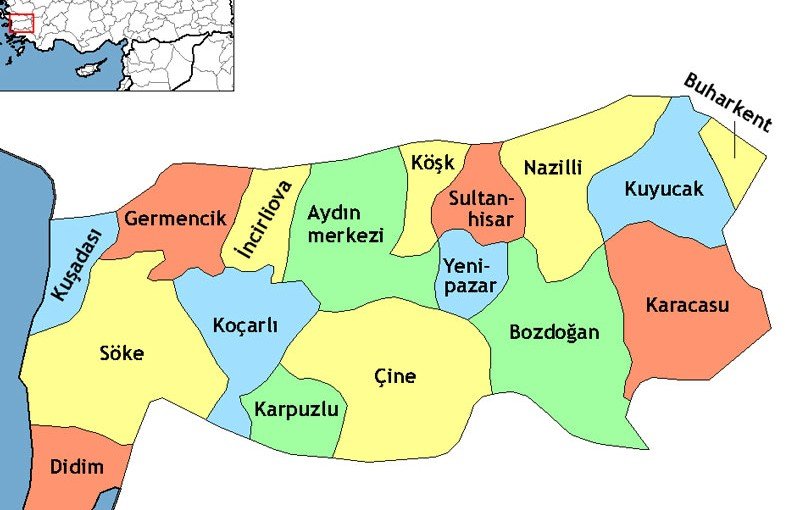
Karacasu is a district located in the southeastern part of Aydın. It stands out with its mountainous landscape, valleys, river system, cooler climate, and cultural heritage. The district was established in a valley approximately 40 kilometers long, situated between Babadağ to the east and Karıncalı Mountain to the west. This location is one of the main factors that has shaped both the natural appearance of Karacasu and its settlement and production patterns throughout history.
Karacasu is located approximately 90 kilometers from the city center of Aydın. To its east lies Babadağ district of Denizli, to its west Bozdoğan district of Aydın, to its north Kuyucak district of Aydın, and to its south Tavas and Kale districts of Denizli. With this position, Karacasu serves as a natural transition area between Aydın and Denizli. Its inland location, surrounded by mountains and developed near a valley floor, distinguishes it from the coastal and lowland settlements of Aydın.
The terrain of Karacasu is partly mountainous, rugged, and sloped. Around the district center, valley floors, hillsides, mountain foothills, and higher areas can be seen together. This structure has directly influenced the distribution of settlements, agricultural areas, transportation routes, and local ways of life. Since flat areas are limited, settlement and production activities are generally concentrated around valley floors, river surroundings, and more suitable hillside areas.
Mountains and Valleys
To understand the geography of Karacasu, the valley structure between Babadağ and Karıncalı Mountain is particularly important. The mountainous areas rising to the east and west of the district give Karacasu the appearance of a sheltered and enclosed basin. This has been influential both on the climate and on the settlement pattern.
Karıncalı Mountain is regarded as the highest point of the district. The elevation of the district center is approximately 600 meters. This altitude causes Karacasu to have a cooler climate compared to the lower parts of Aydın. The intense heat experienced in coastal and plain areas during summer is felt more mildly in Karacasu. In winter, due to the elevation, the weather can be cooler and at times harsher.
The mountainous surroundings do not only provide Karacasu with a physical boundary. They also create an important setting for highland life, forest presence, natural resources, walking routes, and rural living. The highlands in the district are important recreational and seasonal living areas for local people, especially during the summer months, with their cool air and natural environment. In this respect, Karacasu offers a natural inland alternative for those seeking relief from the hot climate of Aydın.
Dandalaz Stream and Water Resources
The most important stream in Karacasu is Dandalaz Stream. Rising from the Dedeler area, this stream reaches the Büyük Menderes River and becomes part of the region’s water system. Dandalaz Stream is important not only for the natural structure of Karacasu but also for the development of historical settlements.
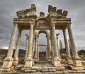
The Ancient City of Aphrodisias is also located in the fertile valley formed by Dandalaz Stream. Known in antiquity as Morsynus, this stream was one of the main elements that shaped the surrounding agricultural areas, settlement patterns, and use of natural resources. Since proximity to water resources has been a determining factor for settlement continuity throughout history, the Dandalaz Valley holds a special place in understanding the historical settlements in and around Karacasu.
River valleys create more suitable areas for agricultural production in Karacasu. Despite the mountainous and rugged surroundings, soil cultivation, garden agriculture, and local production activities have been able to develop on valley floors. For this reason, the geographical character of Karacasu should be evaluated not only through its mountains but also through the waterways and fertile passage areas between them.
Climate Characteristics
Karacasu is generally under the influence of the Mediterranean climate. However, the district’s elevation and mountainous structure cause its climatic conditions to differ from the coastal and lowland parts of Aydın. While summers in Aydın are generally hot and dry and winters are rainier, Karacasu experiences colder winters and cooler, drier summers due to the effect of altitude.
This climate affects the district’s vegetation, agricultural production patterns, and daily life. The more noticeable coolness during summer strengthens Karacasu’s highland character. In winter, temperature drops are felt more strongly in higher areas. Therefore, Karacasu is one of the districts in Aydın that has a more transitional climate and an inland character.
The climate of the district also contributes to the diversity of the natural environment. The maquis and forest communities seen across Aydın vary in Karacasu according to the district’s topography and different elevation levels. Mountainous areas, forested regions, valley floors, and agricultural lands coexist. This diversity enriches the natural landscape of Karacasu.
Vegetation and Natural Environment
The natural environment of Karacasu consists of a landscape formed by mountainous terrain, valley systems, forested areas, and agricultural lands. While higher parts of the district contain cooler and more forested areas, valley floors stand out as more suitable zones for agricultural production.
Although the general climate and vegetation characteristics of Aydın are also seen in Karacasu, the district’s elevation and inland position give this structure a distinct character. Maquis communities, pine species, rural vegetation, and agricultural areas complete the district’s natural appearance. This diversity gives Karacasu value in terms of both rural life and nature tourism.
The highlands of the district have an important place in local life with their clean air, water sources, green texture, and recreation areas. Highlands such as Nacıpınar, Tekke, Ataköy, Ballıpınar, Sürmese, Dedeoluk, Gölcük, Gürlek, Yuva, Çatalarmut, and Kahvederesi are among the main areas that reflect the natural richness of Karacasu. These highlands become important points of attraction for local people and visitors during summer with their cooler climate.
The Geographical Connection with Aphrodisias
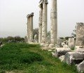
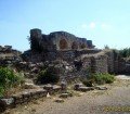
The geographical structure of Karacasu is highly important for understanding the development of the Ancient City of Aphrodisias. Aphrodisias is located within the boundaries of Geyre Neighborhood in Karacasu, on a plateau approximately 600 meters above sea level in the fertile valley formed by Dandalaz Stream. This location provided the ancient city with proximity to both agricultural production and natural resources.
The marble deposits in the region also played an important role in the historical development of Aphrodisias. The marble quarries located to the north of the city, on the slopes of Babadağ, were decisive in the rise of Aphrodisias as a center of sculpture and architectural production in antiquity. The high-quality marble resources of the region supported the city’s reputation in art and sculpture during the Roman period.
For this reason, the geography of Karacasu should be evaluated not only through its natural characteristics but also through its influence on cultural history. Mountains, valleys, the river system, marble resources, and the plateau structure formed the physical environment in which Aphrodisias developed. Today, Aphrodisias plays a major role in the worldwide recognition of Karacasu, yet one of the factors that made the importance of Aphrodisias possible was this special geographical setting of Karacasu.
Settlement and Transportation Structure
The settlement pattern of Karacasu has largely been shaped by the possibilities offered by the topography. The mountainous and rugged structure has caused settlements to develop mostly on valley floors, suitable parts of hillsides, and points close to transportation routes.
The district’s location between Aydın and Denizli has given the region the character of a transition area throughout history. Although Karacasu is far from the city center of Aydın, it maintains natural and administrative connections with surrounding districts such as Kuyucak, Bozdoğan, Tavas, Kale, and Babadağ. These connections are influential in the district’s social and economic relations.
Karacasu is an important center in terms of access to the Ancient City of Aphrodisias. Most visitors reach the ancient city through the Karacasu and Geyre route. This strengthens the district’s relationship with tourism and makes its geographical location more valuable in terms of cultural visitor routes.
Natural and Cultural Richness of Karacasu
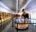
Karacasu draws attention not only with its mountains and valleys but also with its natural and cultural values. The Ancient City of Aphrodisias and the Aphrodisias Museum are the district’s most important cultural heritage sites. In addition, the Karacasu Ethnography Museum contributes to the district’s local identity with objects reflecting the region’s recent social and cultural past.
Pottery is also an important traditional production field in Karacasu. Pottery made from the region’s distinctive red clay is a valuable example of how the district’s natural resources have been transformed into cultural production. The quality of the soil, production tradition, and manual craftsmanship come together to give Karacasu pottery its distinctive character.
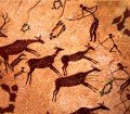
In terms of natural areas, Sırtlanini Cave is also one of the prominent places around Karacasu. With its stalactites and stalagmites, biodiversity, and natural formations, the cave reflects the geological richness of the district. The mountainous and karstic character of Karacasu has created a suitable environment for the formation of such natural features.
When these values are considered together, Karacasu has a multilayered district identity where nature, history, archaeology, handicrafts, and rural life intersect.
The Impact of Geography on Local Life
In Karacasu, geography is one of the main determinants of daily life. The mountainous structure and elevation directly affect settlement patterns, production areas, transportation, and climatic conditions. Valley floors offer more suitable areas for agricultural production, while higher areas are important for highland life, forested zones, and natural resources.
The district’s cooler summers help keep highland culture alive. The mountainous surroundings strengthen the relationship between local people and nature. The soil structure provides a basis for the development of traditional production such as pottery. Marble resources directly influenced the artistic and architectural identity of Aphrodisias in antiquity.
For this reason, the geographical structure of Karacasu should not be considered merely as a physical description. The district’s history, culture, production methods, tourism potential, and local identity have all been shaped on this geographical foundation.
Conclusion
Karacasu is one of the most distinctive districts of Aydın, with its valley structure extending between Babadağ and Karıncalı Mountain, its elevation of approximately 600 meters, its natural environment fed by Dandalaz Stream, the altitude-influenced characteristics of the Mediterranean climate, and its rich cultural heritage.
While its mountainous and rugged structure gives the district a strong natural character, its valleys and river system have created suitable areas for settlement and production. The geography of Karacasu was also decisive in the development of the Ancient City of Aphrodisias. Its fertile valley structure and marble resources supported the historical importance of the ancient city.
Today, Karacasu should be evaluated as a multifaceted district with its natural beauty, highlands, traditional pottery, ethnographic heritage, and the world-renowned Ancient City of Aphrodisias. In this respect, the geographical structure of Karacasu is not only a description of its physical environment but also a fundamental element that shapes the district’s historical memory, cultural identity, and tourism potential.